UTEC’s Jim Edmunds explains how the company’s geoROV tool can assist with geotechnical surveys.
Geotechnical surveys are a prerequisite for establishing engineering soil parameters to enable robust and efficient seabed interaction design solutions – foundation design, on-bottom stability, excavation assessment, geohazard evaluation, etc. There are a number of methods in common use for acquiring the soils data including in situ test methods, such as cone penetration testing (CPT) and T-bar testing, as well as recovery of physical soil samples for subsequent logging and laboratory testing. Historically geotechnical surveys have been conducted using standalone seabed samplers and in situ test machines deployed on lift wires or using a geotechnical drilling system.
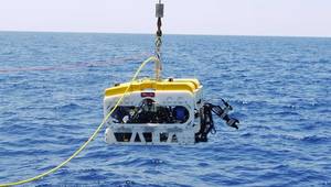
In 2010, UTEC Geomarine introduced a new ROV-deployed geotechnical survey tool, the geoROV CPT and Sampler. The geoROV system is a plug-and-play addition to a work-class ROV spread comprising a linear drive unit with control and real-time data acquisition. The system can be flown to the required location and works in water depths to 3000m, where it can be precisely positioned and in situ test data or soil samples acquired. Multiple in situ tests can be completed on a single dive; in excess of 50 tests have been completed in a single 12hr shift.The geoROV linear drive unit is capable of delivering around 15kN of thrust force, but in order to use this force without jacking the conveyance vehicle off the seabed, sufficient reaction force must be available. Some vehicles (such as trenching machines) are sufficiently heavy to provide the full reaction, but a free-flying ROV can typically only deliver up to 0.4kN reaction force using a combination of negative buoyancy and vectored down-thrust. An ROV-delivered 0.4kN is sufficient to penetrate up to 3m in loose sands or low to intermediate strength clays, but for deeper penetration in stronger soils, more reaction force is necessary.
In 2013, the geoREACT tool skid was introduced to increase the capabilities of the free-flying ROV deployment. The tool skid utilizes two suction cans to provide additional reaction force in suitable seabeds (i.e., most seabeds, except gravel or strong clay). The geoROV drive unit is mounted above the pair of suction cans and the chassis is attached to the underside of the ROV using a standard, four-point tool-skid connection.
The system is useful where conventional deployment may be technically challenging, hazardous, expensive, or impossible to undertake, and it is also gaining a reputation for efficient operation compared with conventional methods. Additionally, it is often convenient for a contractor to have the ability to recover high quality geotechnical data during their offshore campaign without dedicating the entire spread to the sole purpose of acquiring geotechnical data. The geoROV system can be installed and removed from an ROV in less than an hour, allowing for flexible mission planning in response to events and evolving requirements.
Since inception, the geoROV systems have been used in a wide and interesting range of projects including:
Further advances and innovations in the geoROV tool suite are planned in 2014, including a heavier duty linear drive unit, electric drive version, and ultra-deep water (6000m) capability.
 Jim Edmunds has spent 20 years in the offshore geotechnical industry, four with UTEC Geomarine as technology director. Edmonds has also been heavily involved in developing new technological solutions for seabed investigations starting with miniature CPT equipment in the 1990’s, progressing to a deep water heave compensated drilling spread, and more recently ROV-deployed geotechnical drilling, sampling, and in situ testing systems. In 2010, Jim joined UTEC Geomarine to head up the development of new and innovative subsea technology and to build the integrated consulting and contracting business. He holds a B.Eng (Hons) Civil Engineering from Manchester University.
 Subscribe