There’s a war on: who can produce the fastest inspection ROV with the highest quality data? Elaine Maslin explains.
 |
|
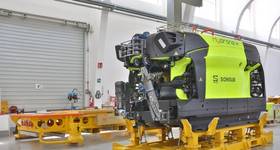
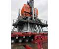
The Surveyor Interceptor. Image from MMT. |
Is it a bird, is it a plane, is it an ROV or an AUV? Well, they’re more like remotely operated vehicles (ROVs) in the shape of autonomous underwater vehicles (AUVs), but on a tether and designed to move faster through the water then standard ROVs.
Pipeline inspection, and doing it faster and more efficiency is top of the list for an industry whose pipeline infrastructure, in the UK North Sea alone, could stretch from the UK to Australia if laid out end to end.
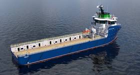
Two companies have come up with specialist tools for the task, as well as seabed and environmental mapping. Swedish marine survey firm MMT, with partner Reach Subsea, is calling its unit a Survey ROV, specifically, the SROV Interceptor. Meanwhile, DeepOcean has developed its “new generation” survey ROV Superior. Both were being presented at Subsea Expo earlier this year.
MMT-Reach
MMT and Norwegian ROV operator Reach Subsea have, working together with Norwegian ROV designers Kystdesign, come up with its concept for a high-speed high flying SROV.
The Interceptor has been designed for maximum stability as well as speed – it can move at up to 8 knots through water, MMT says – but also low noise disturbance, which means survey data is higher quality and can be achieved at higher speeds. It can operate in two modes, high-fly, for acoustic pipeline survey, and low fly, for more detailed inspection on problem areas. The long, flat unit has four rear thrusters, fins port and starboard for maneuvering, driven by 225hp, supplied through an umbilical from its support vessel.
The first unit was built in 2014. In March 2015, its first commercial project was completed over the 140m-long Knarr gas pipeline in 140-400m water depth in the northern North Sea for Gassco. Its task was to check the external condition of the pipeline and rock berm protection after pipe laying.
“The basis for making this SROV was that traditional ROVs were seen as not efficient for this use,” says Ellen Svestad, MMT’s chief commercial officer. “MMT’s founder, Ola Oskarsson, who has been mapping the sea bed since he was 14, said that ‘there must be a way to do this better.’ The traditional ROV is a square box, with limited speed and also limited with image quality because of disturbance, etc. Work on the Interceptor started to give clients a more efficient tool and better data quality and both of those aims have been achieved.”
Interceptor is fitted with a suite of imaging tools and technology. It has three ultra-HD cameras, which are part of a “machine vision” system that automatically create a 3D vision of the survey subject, incorporating metadata, such as time stamps, 3D laser point cloud data and navigation data and using strobe lights for clear images.
Using stills instead of video has very quickly been seen as a better way to acquire better images and data of pipeline condition, as video can, especially at speed, appear blurring when frozen as a still and also takes up a lot more disk space then stills, even when they’re shot at a high-rate. Adding the laser scanner means pipeline ovality can also be assessed.
MMT says the quality of the georeferenced pictures is about 8-10 times higher than that of standard HD video. “From a video you can tell that a thing is round and that a fish was moving, but from a high-resolution still you can make exact measurements and quantity,” says MMT founder Ola Oskarsson.
But, multibeam echosounders (MBES) are still also used on the unit. MMT says the quiet and stable running ROV means the multibeam data has less than 0.5% outliers. “The data is less noisy and more reliable than data acquired by a typical ROV,” Oskarsson says. “Less automatic and manual processing is required.”
The Gassco survey in 2015 was conducted from the Edda Fonn, in early 2015, and exceeded offshore tests which had been carried out on the Europipe 2, carried out in 2014. The unit averaged 3.3 knots and achieved up to 4.5 knots at 4-5m above the pipe while performing MBE survey and achieving 0.1m gridsize data and collecting a full 3D photomosaic.
“In 17 hours and four minutes the Surveyor Interceptor inspected 105km of Gassco’s Knarr gas pipeline in the North Sea from the Knarr gas field, tied to the FLAGS pipeline system on the UK Continental Shelf, a world record,” Oskarsson says.
The launch and recovery system worked in sea state up to 3.8m. The field report was delivered 18 hours after the survey. The final draft report was delivered eight days after leaving the vessel.
The unit went on to survey the world’s longest HVDC link, the 1500km-long Atlantic Super Connector from Iceland to UK, in 40-1200m water depths.

|
|
The Surveyor Interceptor. Image from MMT. |
DeepOcean
DeepOcean’s SROV Superior is a modular ROV, designed to work with an iTMS, or semi-autonomous tether management system.
The ROV’s design is flat and long, with the buoyancy at the top, four rear thrusters and an optional skid for mounting of camera booms, manipulators and other types of skid-mounted tools like geotechnical sampling equipment, 3D geophysical equipment etc. In addition the ROV features a new deployment of the pipetracker, a retractable frame at the front.
 |
|
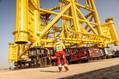
The Superior SROV. Photo from DeepOcean. |
The iTMS, shaped like an inverted wing, is planned to be used during surveys to take the umbilical weight off the ROV while it flies beneath its support vessel.
The aim was for an as stable and as silent as possible ROV, capable of flying at 4 knots at 400m water depth, without the iTMS, and at the same speed at 1000m depth with iTMS, says Trond Hagland, GTO Survey and Geotechnics, DeepOcean.
The modular approach to the design was chosen to allow the ROV to be used for three types of fast ROV surveys: bathymetric survey, acoustic pipeline inspections and visual pipeline inspections. Equipment configurations can be adjusted to suit the purpose of the different types of survey. The latest generation MBEs allows acquisition of high density bathymetric data at high speed.
Using CATHX Ocean high definition laser profiler and HD stills camera system enables acquisition of high density point clouds close to the pipe and high quality stills pictures during acoustic pipeline inspection (typically flying 5m above pipeline). And with the skid, camera booms at the front and the pipetracker lowered, the ROV can quickly switch to close-up pipeline inspection.
After working with Norwegian ROV designers Kystdesign, the first unit, without an iTMS, was delivered to DeepOcean in June 2015, with sea acceptance testing in July. The results were better than expected, Hagland says. The ROV has a drag coefficient of just above 0.2 and speeds in excess of 5 knots were achieved. The iTMS part of the concept has therefore been put on hold until the ROV has been tested at depths in excess of 1000m.
In October 2015, the system was mobilized for work in the North Sea, and the Superior ROV performed all three types of surveys at significantly higher speeds than traditional survey ROVs. Seabed mapping speeds averaged above 5 knots with just 1° pitch and -2° roll constant.
The campaign also performed acoustic inspections of all infield lines in one field. During the inspection, flying 5-7m above the pipelines using MBE and side scan sonar (SSS), data with a digital terrain model (DTM) grid cell size at 0.1m x 0.1m was produced at average speeds up to 3 knots. An as-built visual pipeline inspection of a 105km pipeline was also performed, achieving average speed of 1.3m/s overall.
Pipeline tracking was then successfully performed, tracking a 12in pipeline through gravel intervention down to 1.5m.
“During all three types of survey the ROV was very stable in the water column with limited variations in roll and pitch,” Hagland says.
The next step is adding laser scanning technology, he says, which will allow a greater scope for pipeline inspection at 5-7m above the pipeline and at higher speeds than using MBE while bringing greater data density.
DeepOcean has already tested this technology on an AUV and another ROV. The CATHX laser imaging system was added to the Superior this year for DeepOcean’s main client during the 2016 season.
“The data density of the laser data is vastly greater than the data density of the MBES data with a 20-fold increase on the MBEs data density,” DeepOcean says. “The laser detects features far better than the MBES partly due to its increased data density.”
DeepOcean says further speed improvements will be made by using a launch and recovery system with a thinner umbilical. But, with faster speed, sensors and video quality also need to step up.
 Subscribe