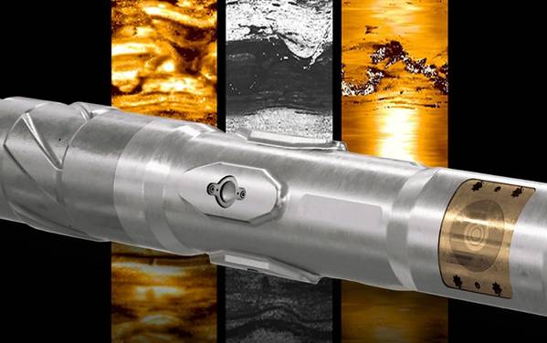
A new high-definition dual-imaging-while-drilling service from Schlumberger has been introduced to overcome geomechanics-related challenges and provide geological characterization in real time.
The new service, TerraSphere, introduced at the SPE Offshore Europe Conference and Exhibition in Aberdeen on Tuesday, applies a logging-while-drilling dual-physics imager for oil-based mud for drilling oil and gas wells, Schlumberger said. It incorporates electromagnetic (EM) and ultrasonic measurements that enable multiple high-resolution borehole images in nonconductive mud. This reveals enhanced details for geological, petrophysical and geomechanical interpretation to uncover subtle variations in the subsurface caused by stratigraphic or structural properties that impact wellbore stability. The real-time transmission of images with these enhanced details enables drillers to make better-informed decisions during the near-wellbore stress interpretation process.
“Drillers have been unable to visualize, in real time, subsurface features when drilling with oil-based mud,” said Tarek Rizk, president, Drilling & Measurements, Schlumberger. “The TerraSphere service delivers geological and geomechanical data that not only saves logging time and related rig costs, but also reduces the potential risk for lost circulation of drilling muds into formation fractures.”
More than 30 field trials were conducted with the TerraSphere service in the Gulf of Mexico, Middle East, North Africa, North Sea and US land. These trials included imaging for structural and stratigraphic analysis, revealing breakout fractures that enabled drillers to avoid mud loss, Schlumberger said, adding, the new service acquired additional and higher definition data, reducing subsequent operational time and improving net-to-gross ratio in the payzone.
In the North Sea, a customer used the TerraSphere service in a complex reservoir in Balder Field. Dual imaging while drilling delineated sand injectites in the reservoir and removed ambiguity from conventional logs, providing more accurate characterization through increased reservoir coverage to maximize production potential. The resolution captured by ultrasonic images is now refined to millimeters—previously possible only with wireline imagers.
 Subscribe