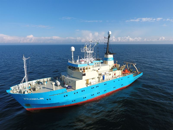
The subsea field work for the Greenlink interconnector, one of Europe’s most important infrastructure projects, gets under way with the launch of the first of MMT’s survey vessels, MV Franklin.
The offshore and nearshore surveying along the proposed route of the electricity link between the UK and Ireland is expected to take approximately 40 days, depending on weather conditions. MMT were awarded the contract for the Greenlink Marine Survey (GMS) by Greenlink Interconnector Ltd in August.
Further survey work along the 170km marine route will be undertaken by vessels MV Seabeam, MV Edda Fonn and RED7 Jack-up rig Seariser 2.
The survey area is between Freshwater West, Pembroke, Wales and Baginbun, Co Wexford, Ireland. A Notice to Mariners has been issued for the area.
The objective of the GMS is to acquire all appropriate data for the confirmation of a preferred route for the High Voltage Direct Current (HVDC) cable system. The surveys will also contribute to the cable burial risk assessment and provide information for the planning applications ensuring that the final route selected is designed sympathetically to the existing marine environment.
Greenlink is a proposed 500MW electrical underground and submarine interconnector, connecting the UK National Grid system at Pembroke substation in Pembrokeshire, Wales to the Irish network at Great Island substation in County Wexford, Ireland. The privately-financed €400 million ($471 mln) project is being developed by Greenlink Interconnector Limited, a subsidiary of Element Power. The commencement of the GMS represents a significant milestone in the development of the project, in preparation for the start of construction scheduled for 2020.
MMT’s geophysical marine survey work comprises intertidal topographic survey, geophysical / hydrographic nearshore and offshore data acquisition, geotechnical investigations with vibrocoring / piston coring and cone penetration testing (PCPT), environmental sampling and imagery, infrastructure crossing survey with ROV, UXO survey, and geotechnical boreholes to inform horizontal directional drilling.
These operations shall provide high resolution and accurate measurements of the bathymetry and seabed features and the shallow geological conditions along the route(s). This will be supplemented by localized unexploded ordnance (UXO) surveys, environmental sampling and imagery as well as surveys of infrastructure crossings using an ROV.
 Subscribe