With well data often scarce, many deep water Gulf of Mexico operators rely on the structural images and elastic properties derived from seismic when evaluating the probability of success and estimating reserves in prospective fields. Vincent Vieugue suggests this is not enough.
 |
|
Fig. 1: Regional reservoir interval and the initial interpretation that relied purely on seismic data and geological knowledge, compared with an updated transverse resistance (TR) map that incorporates the CSEM data. Images from EMGS. |
Seismic remains highly effective in generating structural and stratigraphic information as well as volume estimation parameters, such as gross rock volumes. While there have also been significant advances in areas such as amplitude versus offset (AVO) and seismic inversion, information gaps still remain when it comes to fluid content and the estimation of hydrocarbon volumes.
Questions still remain as to whether AVO responses are caused by fluid or lithological variations with a potentially negative impact on well placement and there are also issues around seismic’s ability to interpret salt body geometries and create clear sub-salt images.
While seismic and reverse time migration (RTM) tend to provide a good definition of top-salt interfaces, where there is a high seismic impedance contrast, a partial definition is often the best operators can hope for when it comes to salt flanks and the base of salt and sub-salt. Distorted seismic wave fields, scattering, irregular illumination, complex velocity distribution and incomplete velocity models are often the norm.
Seismic needs support if it is to provide a complete picture of the subsurface and to avoid scenarios where prospects are identified as having strong seismic, AVO and geological potential, but are later found to be lacking in fluid content. One source of such support is 3D controlled source electromagnetic (CSEM).
3D CSEM, when integrated with seismic data, can lower exploration costs and increase discovery rates in the US and Mexican Gulf of Mexico (GOM).
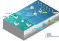
3D CSEM surveys
3D CSEM data maps resistive anomalies in the subsurface, where the larger the resistive body, the greater the response. This is due to the electrical resistivity of the subsurface being a physical property that strongly correlates with the fluid content and saturation of hydrocarbon reservoirs.
Such EM methods are also well-suited for imaging sub-salt sediment structures, where an intelligent well-constrained attribute correlation between inverted resistivity and compressional velocity in sediments can be used to refine the seismic velocity model and produce better seismic imaging for basement structures.
In addition, EM measures different rock properties to seismic and is subsequently unperturbed by the scatter and refraction that causes seismic such difficulties, accurately picking out the base of the salt in depth by the change of resistance and then applying this to the velocity model.
Whether in sub-salt fields or fields with other geological characteristics, integrating EM data into the exploration workflow to support seismic allows for a better classification of prospects through the downgrading or upgrading of the probability of finding hydrocarbons and an improvement in the evaluation of the size of the accumulation.
 |
|
Fig. 2: L – Seismic interpretation. R – Seismic and EM. |
3D CSEM in the Gulf of Mexico
EMGS has a long history of conducting CSEM surveys in the GOM.
Since 2010, EMGS has acquired over 16,000sq km of 3D CSEM in the Mexican GOM for Mexican operator Pemex over >40 identified prospects.
In one example for Pemex, the prospect was located approximately 1800m below mudline and consisted of an anticlinal structure situated within a compressional belt, where a variety of compressional structures occurred at various scales. Overlying the main structure, a seismic sequence was present that was almost devoid of faults, providing just enough sealing capacity for the entire structural closure.
Figure 1 illustrates the regional reservoir interval and the initial interpretation that relied purely on seismic data and geological knowledge. It shows a reasonable conformance with the structural closure and an association with anomalous seismic amplitudes. A white line polygon also shows the extent of the seismic anomaly. The main risk here is the hydrocarbon saturation/seal, as the column height is quite large.
In the 3D CSEM inversion data, an Rv anomaly is present that has a good fit with the seismic amplitudes within the structural closure and reduces the risk of low saturation being the origin of the derived seismic amplitudes. It also confirms the large areal extent of the accumulation.
Figure 1 shows the updated transverse resistance (TR) map that incorporates the CSEM data and the extent of the resistivity anomaly associated with the target.
It’s important to note the close spatial correlation between both the seismic and the CSEM and the highly resistive feature to the south east of the main structure that was interpreted as being non-hydrocarbon related, based on the seismic indicators of resistive lithologies shown elsewhere in the survey.
As a result of this interpretation, both the probability of success and reserves of this prospect were updated. The target was then drilled and encountered two hydrocarbon-filled reservoir intervals, thereby confirming the interpretation derived from the 3D CSEM data working alongside the 3D seismic and the regional geology.
 |
|
Fig. 3: Subsalt stratigraphy is improved after a joint inversion of seismic and 3D EM data. Seismic data and processing courtesy Schlumberger. L – WAZ seismic only. R – WAZ seismic and CSEM/MT. |
3D CSEM in salt
The applicability of CSEM when it comes to salt can also be seen in another target in the deepwater GOM. In this case, conducting a resistivity survey through EM and then incorporating the reinterpreted geobodies back into the seismic via migration led to significant benefits.
The survey targeted a salt diapir with potential hydrocarbon reservoirs at the flanks where 3D seismic was available and where the approximate location of the salt diapirs were known. There was a need to identify AVO responses and improve the interpretation of the salt flank and the base of salt.
Through the acquired CSEM data along with additional data, such as well logs and previously acquired CSEM, a robust initial resistivity model for 3D CSEM anisotropic inversion was established.
A vertical and horizontal resistivity grid (TIV anisotropy) defined the model with salt bodies based on seismic data interpretation included in the initial model to enhance convergence in inversion.
Figure 2 shows the results of the 3D CSEM inversion overlain with 3D seismic with the vertical resistivity component illustrated and the black lines representing the salt top and base interpreted from seismic. The 3D CSEM inversion result showed a salt root that was not previously mapped based on seismic data alone.
Figure 3 shows how subsalt stratigraphy is improved after a joint inversion of seismic and 3D EM data with the seismic data and processing, courtesy of Schlumberger.
The imaging results demonstrate that CSEM data has the potential to enhance interpretation in complex salt-affected areas with resistivity data within the seismic velocity model enhancing the resolution of seismic sub-salt imaging. In such cases, a 5-10% improvement in the imaging of the structure post-migration can have a huge impact on future drilling and appraisal decisions.
Looking north
 |
|
Fig. 4: Wilcox resistivity map from the Daybreak survey in Alaminos Canyon. |
Looking North from Mexican waters and building on the years of experience with Pemex, EMGS has recently completed an 1850sq km CSEM survey in the Alaminos Canyon area of the US GOM.
In one part of the survey in the Great White field, around the Perdido installation, the survey dropped 130 receivers and towed 702km of source lines in 1700-3000m water depth. Receiver nodes were “free falled” into position (with all dropped within specification and 88% within 100m of their planned location) and the source towed 30m above the seafloor to transmit an EM signal into the subsurface.
In this case, the integrated interpretation of CSEM (as seen in the Wilcox resistivity map in figure 4) and seismic has been a valuable tool for companies participating in lease sale 238, with 14 operators submitting 93 bids in August 2014. The CSEM and seismic data will also continue to play a key role in future leasing decisions and well placements in the area.
Accessing different data sources
From basin evaluation and frontier exploration right through to field development, CSEM enables Pemex and other operators in the Gulf of Mexico and around the world to reduce the uncertainties associated with an incomplete geological model and generate a more accurate assessment of the probability of success and reserves estimation.
While seismic continues to be the “go to” technology for offshore exploration, it’s only by accessing a variety of different data sources and technologies that a complete picture of the subsurface and its economic potential can be developed. 3D CSEM is a crucial element of this.

Vincent Vieugue is executive vice president of sales & marketing at EMGS. He has an MSc in oceanography and in geophysics from Toulon University and Strasbourg University in France, respectively. Vieugue has worked for over 20 years in the oil and gas industry, starting in 1994 with Schlumberger, mainly within WesternGeco. Vieugue has also worked with Roxar, and he joined EMGS in 2014 .
 Subscribe