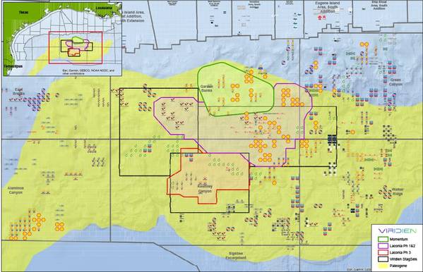
French seismic firm Viridien has taken ownership of seismic field data from the Momentum survey, which will be incorporated into Laconia, the company’s sparse ocean bottom node (OBN) program in the U.S. Gulf.
The new coverage will extend Viridien’s OBN footprint by approximately 143 Outer Continental Shelf blocks (around 3,343 sq km) and be integrated with Laconia Phases I and II to enhance subsalt imaging in the northern Garden Banks protraction area.
Leveraging Sercel’s Tuned Pulse Source (TPS), which enables deeper diving-wave penetration, and Viridien’s elastic full-waveform inversion (E-FWI), the expanded Laconia dataset will offer a step-change in resolving complex salt geometries and deformed shale, unveiling new exploration opportunities in the Paleogene trend.
“Incorporating Momentum data bolsters Viridien’s deepwater OBN coverage and underscores our leadership in OBN imaging. It reinforces our commitment to cutting-edge Earth data solutions and advances our ability to illuminate complex Paleogene geology as Gulf exploration evolves,” said Joe Zhou, SVP Americas, Earth Data, Viridien.
 Subscribe