|
| Image: PNG seismic/ Searcher Seismic |
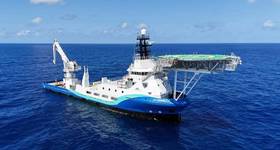
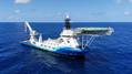
Searcher Seismic has announced the Haere 2D Seismic Survey offshore Papua New Guinea (PNG).
The survey, in cooperation with the Department of Petroleum and Energy (DPE) and project partner BGP, comprises 17,000km of 2D long-offset, high resolution, broadband seismic over the Gulf of Papua.
The BGP Explorer has now mobilized for the project.
Rachel Masters, Global Sales Manager for Searcher, said Haere is a grid of modern, high quality data that will be fundamental in assisting the re-interpretation of the geology in the Gulf of Papua, and the identification of prospective structural and stratigraphic trends that can be used for regional evaluations and future detailed seismic survey designs.
“Deep grabens in the area are believed to contain extensive Mesozoic and Palaeozoic sediments,” said Masters. “Which may be associated with multiple unexplored petroleum systems, highlighting the prospectivity of the Gulf of Papua.”
“It is an exciting time in PNG for oil and gas exploration and we are very pleased to again be working with DPE in the area,” Masters added.
The new survey brings Searcher’s total data library in the Gulf of Papua to 58,000km.
 Subscribe