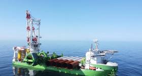
Searcher Seismic has commenced the acquisition of the Buscador Near-Shore 2D seismic survey, offshore Mexico, using the BGP Pioneer vessel.
 |
|
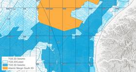
Map of the Buscador Near-Shore 2D Seismic Survey, from Searcher Seismic. |
The project comprises 11,200km of high quality, long-offset 2D data and specifically targets the near shore areas covering rounds 2, 3 and 4.
The data, which will be processed at DownUnder GeoSolution’s Houston facility, covers both proven mature and semi-mature regions and also enters into shallow-water areas with limited, to no drilling activity to date.
“The survey has been designed to tie key exploration wells and to also establish a regional framework for the entire prospective near-shore Mexican area,” said Rachel Masters, global sales manager for Searcher.
The survey design was optimized using Searcher’s Seisintel database, which provides leading geospatial products derived from the Automatic Identification System.
“Considering the vast amount of modern data recently acquired in Mexico, it was invaluable to use the Seisintel database during planning to ensure all lines are uniquely positioned as well as being complementary to the existing data,” Masters added.
The survey is the second seismic project for Searcher in the Gulf of Mexico, joining the 17,700sq km, South Campeche Ultracube 3D Reprocessing project which commenced last month.
Read more:
 Subscribe