Seismic acquisition activity is increasing in the offshore Ireland Atlantic margin ahead, with concurrent 2D and 3D surveys being shot in the basin.
Today, Providence Resources announced a new 2D seismic survey had started over Frontier Exploration License (FEL) 6/14, offshore Ireland, containing the Newgrange prospect, says Dublin-based independent exploration firm and license operator Providence Resources.
The survey is part of a multiclient 2D program using the M/V Harrier Explorer under contract by Polarcus MC and Seabird Exploration covering 2500km of new ‘long offset 2D seismic reflection data. About 1000km will be focused on the Newgrange prospect, together with associated seismic well tie lines.
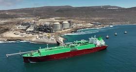
Meanwhile, Dolphin Geophysical's M/V Sanco Sword (pictured) last week started a 750sq km 3D seismic survey in 300-650m water depth about 140km offshore western Ireland over FEL 1/14, containing Spanish Point South, operated by Cairn Energy subsidiary Capricorn Ireland.
Early in July, survey operations started on the Providence Resources-operated Drombeg oil prospect, in FEL 2/14, in the Southern Porcupine basin, about 135 miles off southwest Ireland. Polarcus was due to acquire 1065sq km of 3D data over Drombeg.
The survey, by the Polarcus Amani, is part of a 4400sq km 3D multiclient survey in the Southern Porcupine basin, being acquired in collaboration by ION GeoVentures and GeoPartners, and comprises the largest 3D multiclient 3D survey offshore Ireland. The Polarcus Amani is towing a 1350m ultra-wide deep-tow spread comprising 10 by 8000m solid streamers.
The increase in activity comes as operators seek to meet license commitments, further delineate prospects, and look to gather information in the Irish Altantic offshore, ahead of the next Irish offshore licensing round.
There is a lot of acreage to go for. Offshore Ireland is six times the size of the North Sea and its Atlantic margin area alone has a 10 billion boe yet-to-find reserves potential, Providence Resources' CEO Tony O'Reilly said earlier this year.
The Newgrange prospect area lies in about 1000m water depth in the Goban Spur Basin about 260 km off the south west coast of Ireland.
The 2D survey over Newgrange will also tie into Polarcus’ South Porcupine multiclient 3D survey and the Dunquin North exploration well, which has proven an oil exploration play concept in Cretaceous-aged carbonates in the area, said Providence.
John O’Sullivan, Providence's technical director of Providence, said: “This survey (Newgrange), in tandem with the two 3D seismic acquisition programmes currently being acquired over our Drombeg prospect and our Spanish Point South prospects, will give valuable new data over the North and South Porcupine basins, as well as the Goban Spur Basin."
Read more:
 Subscribe