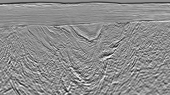
Viridien has completed the seismic imaging for the Selat Melaka multi-client 2D seismic program, covering the offshore area of the Langkasuka Basin in Malaysia.
The newly available final seismic dataset clearly indicates the presence of a previously unseen Pre-Tertiary fold and thrust belt, extending offshore across the unexplored area.
The new high-resolution long-offset dataset provides extensive seismic coverage and significantly enhanced imaging over this promising area.
Viridien’s subsurface imaging experts have applied the company’s latest high-end imaging technologies, including full-waveform inversion and Q-tomography, for the first time in the Langkasuka Basin.
“We are delighted to have successfully completed our first multi-client project offshore Malaysia, that leverages over 40 years of experience processing seismic data from one of the country’s major basins.
“We are confident that this ultramodern data set will support the efforts of Malaysia Petroleum Management, Petronas in promoting open acreages in Selat Melaka and spur exploration in this frontier area located near a number of proven large discoveries,” said Dechun Lin, EVP, Earth Data, Viridien.
 Subscribe