Seismic acquisition began on the new Polarcus Capreolus 3D multi-client project over the Phoenix area in the Rosebuck basin, offshore Western Australia.
The area contains the recent Apache-operated Phoenix South-1 oil discovery, estimated to contain up to 300MMbbl in place. The survey area will cover the majority of the four exploration permits making up the Phoenix area, says Carnarvon Petroleum, a partner in the four areas with Apache: WA-435-P, WA-436-P, WA-437-P and WA-438-P.
"With the Capreolus MC3D, the joint venture partners will have modern 3D seismic data covering some 10,000sq km of the approximate 22,000sq km covered by the four contiguous Phoenix area permits," says Carnarvon. "This 3D seismic data is specifically intended to enable future exploration within the primary Triassic and Jurassic reservoirs within the Phoenix area. Additionally, a new two-dimensional seismic acquisition program (the Bilby MC2D) will acquire modern 2D seismic data over most of the remaining acreage holding. Collectively the new data will provide important new insights regarding the regional geology and its prospectivity."
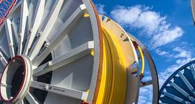
The survey is using two high-performance, 12-streamer Polarcus vessels, Polarcus Amani and Polarcus Asima, operating in tandem in order to maximize production.
The Capreolus 3D multi-client project comprises a substantial 15,000sq km and has been designed by Polarcus' in-house experts in collaboration with the project underwriters to provide a basin-wide high quality broadband 3D seismic dataset over and adjacent to the Phoenix South-1 oil discovery announced in 2014.
The basin is one of the few remaining under-explored parts of Australia's North West Shelf and considered to have the potential to become a major new oil province. The Phoenix South-1 well was 180km north of Port Hedland in 133m of water depth.
The data acquisition phase is estimated at approximately eight vessel months (four calendar months), with the resultant data being processed through a pre-stack depth migration routine by DownUnder GeoSolutions in Perth. Final data products are expected to be available within 2Q 2016.
Carnarvon and partner Finder Exploration were the first to license 3D seismic data in the Phoenix area that now contains the Phoenix South-1 oil discovery. The first 3D seismic acquisition in this area (the Phoenix MC3D) covered 1,100sq km and was acquired late in 2010 / early 2011.
In late 2011 / early 2012 a second 3D seismic acquisition program (the Zeester MC3D) acquired an additional 3854sq km. The current joint venture partners have recently agreed to license this data following the success of the Phoenix South-1 well.
Carnarvon said the objective of the latest data will be to identify new and refine currently identified prospects and leads for possible future drilling. Carnarvon will invest about $10 million licensing the Zeester and Capreolus 3D seismic data and the Bilby 2D data.
 Subscribe