With industry interest reawakened by recent deepwater, sub-salt gas finds offshore Israel, the eastern Mediterranean and Levantine Basin today loom large on the frontier exploration agenda. Here, Øystein Lie, Thore Sortemos and Per Helge Semb of Petroleum Geo-Services explain why they think a new hydrocarbon province could open up offshore Cyprus and Lebanon in the next few years.
Offshore Cyprus and Lebanon are huge unexplored areas in the eastern Mediterranean. This deepwater area is close to proven offshore hydrocarbon provinces in the Nile Delta and Israel. Until recently, shallow post-salt targets have been the main focus in these areas; however, with recent advances in seismic technology sub-salt plays have been revealed. The recent deepwater, sub-salt gas discoveries offshore Israel have significantly increased industry interest in the eastern Mediterranean and particularly the Levantine Basin. High quality Lower Miocene reservoir sands were discovered in both the Tamar and Dalit wells (Figure 1). Analogues to the drilled structures offshore Israel can be found both offshore Cyprus and Lebanon which may prove to be a new province for oil and gas in the next few years.
When the Republic of Cyprus arranged its first licensing round in 2007, Noble Energy was awarded block 12. The second licence round, scheduled to open this year, will include all the remaining open exploration blocks covering a huge unexplored area.
Petroleum Geo-Services (PGS) has provided the Cyprus commerce, industry & tourism ministry with a dense 2D coverage over the exploration blocks, and one 3D survey. The data covers an offshore area of more than 50,000km2 and forms the basis for a geological report, with interpretation and assessment of the variety of plays in the Herodotus Basin, the Eratosthenes Continental Block, the Cyprus Arc Basin and the Levantine Basin.
The Republic of Lebanon is preparing for its first offshore licensing round and anticipates an announcement this year. It is offering oil and gas companies more than 25,000km2 of highly prospective acreage located north of the oil and gas producing areas of Gaza and Israel. The offshore area is covered by extensive 2D – an extension of the recent 2D dual-sensor (GeoStreamer) survey offshore Cyprus – as well as by 3D seismic data. The data reveals several attractive hydrocarbon plays where the primary focus would be in the Miocene sub-salt plays, the Jurassic/Cretaceous horst blocks and Miocene stratigraphic pinch-outs.
Seismic technology
The recent 2D seismic data was acquired with the GeoStreamer which differs from a conventional streamer in that it has two recording sensors.
A pressure sensor in a conventional towed streamer always records two wavefields that interfere with each other. The two wavefields are the up-going pressure wavefield propagating directly to the pressure sensor from the earth below and the down-going pressure wavefield reflected downwards from the free (sea) surface immediately above the streamer. Thus, every recorded reflection wavelet from conventional marine streamers is accompanied by a ghost reflection from the ocean’s surface.
The PGS dual-sensor streamer (GeoStreamer) measures both the pressure wave field using hydrophones, and the vertical component of the particle velocity using motion sensors. By combining the data from the two sensors the energy can be separated into up- and down-going parts (Carlson et al, 2007). By considering only the up-going wavefield, the effect of the ghost reflections from the sea surface is removed. When the ghost reflections are removed, the resulting spectrum is flat and broadband thus enabling the user to optimize the data quality, not just for one target depth, but for all depths shallow to deep (Figure 2).
The dual-sensor streamer was towed deep to increase the energy level on the low frequencies and still keep the desired content of high frequencies. The deep tow ensured a quiet environment which, combined with the enhanced low frequency signal, significantly increased the signal-to-noise ratio of the seismic data. Based on experience of the operations in the eastern Mediterranean, the dual-sensor streamer benefits have been seen in three key areas: enhanced resolution of the seismic image both shallow and deep, due to a broader frequency spectrum; better signal penetration revealing sub-salt and deeper targets, which have been valuable for the interpretation; and improved seismic operational efficiency due to less weather down-time.
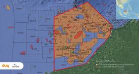
Eastern Mediterranean MegaProject
The continuous seismic coverage from Cyprus to Lebanon (Figure 3) provides an excellent starting point to understand the geological development of this prospective region. Matching and balancing of the entire PGS 2D and 3D seismic database and including third party data in the offshore regions, has been undertaken. A total of 18,000km GeoStreamer 2D data, 18,000km conventional 2D data, in addition to 2900km2 3D seismic data, has allowed interpretation of regional reflectors, with no restriction across country borders. The data has provided an improved understanding of the nature of the hydrocarbon systems, improved interpretation of plays and prospects, and clearer understanding of the hydrocarbon potential of the different basins in the area.
Six key regional horizons have been interpreted across the data set. The horizons for interpretation were chosen based on reflector continuity and regional character, in order to enable us to delineate the different tectonic elements in the area such as the Levantine Basin, the Cyprus Arc, the Eratosthenes Seamount and the Herodotus Basin. The interpretation has also outlined several prospects and leads at the potential reservoir horizons.
While no wells have been drilled within the study area, the hydrocarbon charge system is interpreted to have potential source intervals in possible Middle Jurassic and Upper Cretaceous- Lower Tertiary and Lower Miocene. The isolated structural setting of the Levantine Basin favours the deposition of source rocks, and it is considered highly unlikely that no source rocks are present in such a thick sedimentary succession. Nearby discoveries in the NEMED block in Egypt, the recent deepwater Lower Miocene Tamar and Dalit discoveries and exploration wells drilled in the shallow water and onshore areas of Israel and Gaza have already proved the presence of a working hydrocarbon system in both the Herodotus and the Levantine Basin. Proven reservoir facies, in the Cenozoic of the eastern Mediterranean, occur in a variety of depositional settings and frequently display god reservoir quality and we believe that there is a strong likelihood that clastic and/or carbonate reservoirs will be present in the current area of interest. Preliminary regional interpretation indicates, among other possibilities, the presence of basin floor fan systems, channel systems and carbonate build ups.
The sedimentary basins of the eastern Mediterranean contain a wide range of trapping styles.
The most prospective trap types in the deepwater Levantine Basin are currently considered to be sub-salt NE-SW trending folds and NNE-SSW trending faulted anticlinal Syrian Arc traps. But other trap types such as tilted fault blocks, horst blocks and stratigraphic traps have also been identified and the interpretation has already revealed several large structural analogues to the Tamar discovery in the Levantine Basin. The thick, extensive Messinian Evaporite succession that characterizes the geology of the eastern Mediterranean should constitute an effective regional top seal.
As with its larger counterparts in the North Sea and West Africa, the EMMP is planned to expand, using a phased approach, to include data from neighbouring countries offshore. But today it is already supplying interested parties with an invaluable head start prior to the upcoming licensing rounds in both Cyprus and Lebanon.
Conclusions
Offshore Cyprus and Lebanon are offering highly attractive acreage for exploration. A recent regional GeoStreamer 2D seismic data grid has improved the data coverage and quality to reveal new subsalt plays. The Eastern Mediterranean MegaProject is providing seamless seismic data coverage across country borders to increase the understanding of the hydrocarbon systems and potential of the eastern Mediterranean. OE
 Subscribe