Ocean floor mapping is being completely re-thought, with the help of drones, swarms of underwater vehicles and unmanned surface vehicles. Elaine Maslin reports.
 |
|
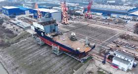
Team Tao’s BEM concept. Images from SMD. |
We know more about the surface of Mars than we do about the ocean floor, and that’s not good enough, says supermajor Shell. To spur technologies that could help understanding of the deep, Shell launched a US$7 million competition, the Shell Ocean Discovery XPRIZE.
The challenge is to create technologies that could autonomously map the seabed down to 4000m water depth – at super-fast speed. Round 1 will see teams attempt to survey 20% of a 500sq km seafloor competition area in 16 hours, in 2000m water depth, then produce a high-resolution map (at least 5m horizontal resolution and at least 0.5m vertical resolution).
Teams must also bring back five images of an archeological, biological, or geological feature, as well as an image of an object specified by Shell. They must deploy from the shore, with no humans allowed in the competition area.
“To put this challenge into perspective, it can take days to map 500sq km of the ocean using current state-of-the-art technologies,” says Jyotika Virmani, XPRIZE’s senior director for Energy & Environment. “If you want 5m accuracy, mapping can take over a week and requires going out on a ship, which can easily cost over $60,000 per day.”
Existing technologies cannot operate at the large scales needed to cover the ocean, unless they make substantial compromises in mapping, resolution, power and weight of sensors.
Following Round 1, 10 of the 21 semifinalists, selected from 32 initial entries, will go through to Round 2. The second round will challenge them to go down to 4000m, map at least 50% of the 500sq km competition area at 5m resolution, and identify and image at least 10 archeological, biological or geological features at any depth – all within 24 hours. Again, deployment must be from the shore, reaching up to 100km out to sea.
The winner takes a $4 million prize. Two runners up will receive $1 million each. The National Oceanographic and Atmospheric Administration has set a $1 million bonus for the team that can detect the source of chemical and biological signals underwater.
Technologies to be tested in Round 1 include various air and water drones, autonomous underwater vehicles (AUVs), robot swarms, artificial intelligence and data processing platforms. “Some are proposing to use drones as a mechanism to drop subsea instruments into the water, while others are proposing to use drones that not only go through air, but then dive into the watery depths,” Virmani says. “Non-aerial entries include autonomous surface vehicles (ASVs) carrying subsea robots that will return to the ‘mothership’ when their work is done, as well as vehicles and robots that will remain beneath the sea surface from the moment they leave the shore.”
Team Tao
 |
|
Team Tao at work. |
The only UK-based semifinalist, a collaboration between subsea equipment specialist Soil Machine Dynamics (SMD) and Newcastle University, is Team Tao. In 2015, Dale Wakeham, team leader and industrial design engineer for SMD, put the idea to parent company, China’s CRRC Times Electric, which is backing the team’s XPRIZE entry. “By August 2016, we were in China trying to work out ways to solve the problem – mapping 500sq km within 24 hours, with an autonomous system, which could fit into a 20ft container,” he says.
Team Tao is working with Chinese state institutes as well as with UK- and US-based organizations. After seeing what was already available and finding nothing – they looked at a swarm-based approach,” Wakeham says. “Imagine a colony of ants working together and very effectively.”
In a typical AUV deployment, one AUV is lowered into the water, does its mission, then is brought to the surface and the data downloaded. Then, the AUV is recharged and sent off again. Team Tao’s approach would have a swarm of units, which they’ve called bathypelagic excursion modules (BEM), deploying continuously from an ASV. The BEMs would build a picture of the seabed by each taking a snapshot, then returning to the surface for data download and processing. The idea is to have up to 20 BEMs on an ASV, with an aerial drone providing air support and communications.
Team member Hua-Khee Chan, a research associate at Newcastle University’s School of Electrical & Electronic Engineering, says that traditional AUVs are too big and expensive. “To map the same amount of area would cost around £10 million ($12.9 million) for 24 hours,” he says. “Using a swarm of BEM AUVs could cost £1.5-2 million ($1.9-2.6 million) and if one BEM fails, the survey will keep going. Using a swarm approach, you can have a cyclic, continual operation without any system downtime.”
Team Tao’s BEMs are quite unlike traditional AUVs – they travel vertically, with their nose pointing up and a thruster mounted on a gimbal at the base for directional control. The BEMs, measuring about 1m-long and weighing 10kg, would be transported on a ASV and dropped sequentially, at set location. Cycle time would be 30 minutes, instead of eight hours for a traditional AUV. “The inspiration is from marine life,” Wakeham says. “We are taking as much as possible from nature.”
Each BEM would have an onboard altimeter and gyro to maintain heading. Each BEM also knows where the others are, thanks to ultra-short baseline acoustic positioning connected to a single surface beacon on the ASV. Onboard the ASV, there would be a built-in data processing system to strip data from each unit when they surface.
“One of the beauties of making the swarm travel vertically instead of horizontally is that we can leave out a lot of complex technology because dive time isn’t as long,” Chan says. “We have smaller batteries, smaller, cheaper technologies and consumer-grade electronics.” Because the BEMs are smaller, the surface handling system will also be less expensive.
Work at the university on small and low-cost sensor arrays, which leverage software to improve performance, will be brought to bear on the system.
To address the challenges of communicating with an unmanned system up to 100km offshore, the team may initially use satellite systems. However, they are trying to build as much autonomy into the ASV as possible, so that only needed data is sent via satellite back to the shore.
Subsea, programming and naval architecture students from Newcastle University are helping on the project. UK firms are producing the sonar system and the positioning system. Lenovo has provided IT equipment and computational capacity. Fablab in Toulouse, France, is developing a prototype launch and recovery system (LARS).
Team Tao will be able to use the university’s research vessel for sea trials. But first, the team will build a half-scale LARS, then test it in the nearby River Tyne. The team’s base at the university’s Tyne Subsea Technology Centre has a large pressure chamber for testing the BEMs down to a simulated water depth of up to 6000m. Should the team be one of the 10 selected to go into Round 2, it will – as will the others – win $100,000 and have a further year to develop the system.
 Subscribe