Rosneft has completed its 2015 geological exploration program at offshore licenses using 2D seismic survey methods that covered 20,434km in the Kara Sea, Chukchi Sea, and Laptev Sea.
For the first time, 2D seismic exploration was carried out with support of an integrated information system, a joint development of the company and the Arctic Research Center, enabling a real-time monitoring of ice conditions and keeping track of the location of the ice edge as well as the dynamic features of drift-ice fields and ice bodies.
This approach made it possible to extend the operations time window and to move the surveys further north to the areas of active drift-ice fields.
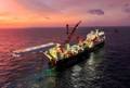
The 3D seismic acquisition covered 2710sq km in waters of the Pechora Sea and the Sea of Okhotsk.
This year Rosneft has constructed two development wells in the Sea of Okhotsk and completed geological engineering surveys in the Pechora Sea (at the Yuzhno-Russky license area). Furthermore, joint ventures of Rosneft and Statoil, carried out geological engineering surveys at two licenses in the Sea of Okhotsk (Magadan-1 and Lisyansky) in support of the 2016 exploration drilling program.
Also, a field geological expedition was arranged to study sedimentary complexes at the Novaya Zemlya and Frantz Josef Land Archipelagos. The survey results are instrumental in identifying future areas of hydrocarbon exploration in the shelf of the Barents Sea and north Kara Sea.
 Subscribe